Water Wars — Weather Weapons and the Engineered Drought
Shutting Down the Dams: Weather Weapons, Water Wars, and the Coming Famine
The Engineered Drought
The official story is that the American West is suffering a “natural megadrought,” the result of bad luck, reduced snowpack, and climate change. But anyone paying close attention to the skies knows better. For decades, NEXRAD radar arrays, HAARP ionospheric heaters, and other RF transmission systems have been operating in plain sight, shaping the jet stream, steering atmospheric rivers, and evaporating moisture before it ever reaches the land.
The result is not random. It is controlled. Rain clouds build up over the Pacific, only to be scattered or redirected. Storm systems that should replenish the Colorado River basin are broken apart before they cross the Sierras. What falls as precipitation is targeted, uneven, and often laced with chemical particulates that further disrupt hydrological cycles.
This is not climate change — it is climate control.
Drying Up the Lifelines
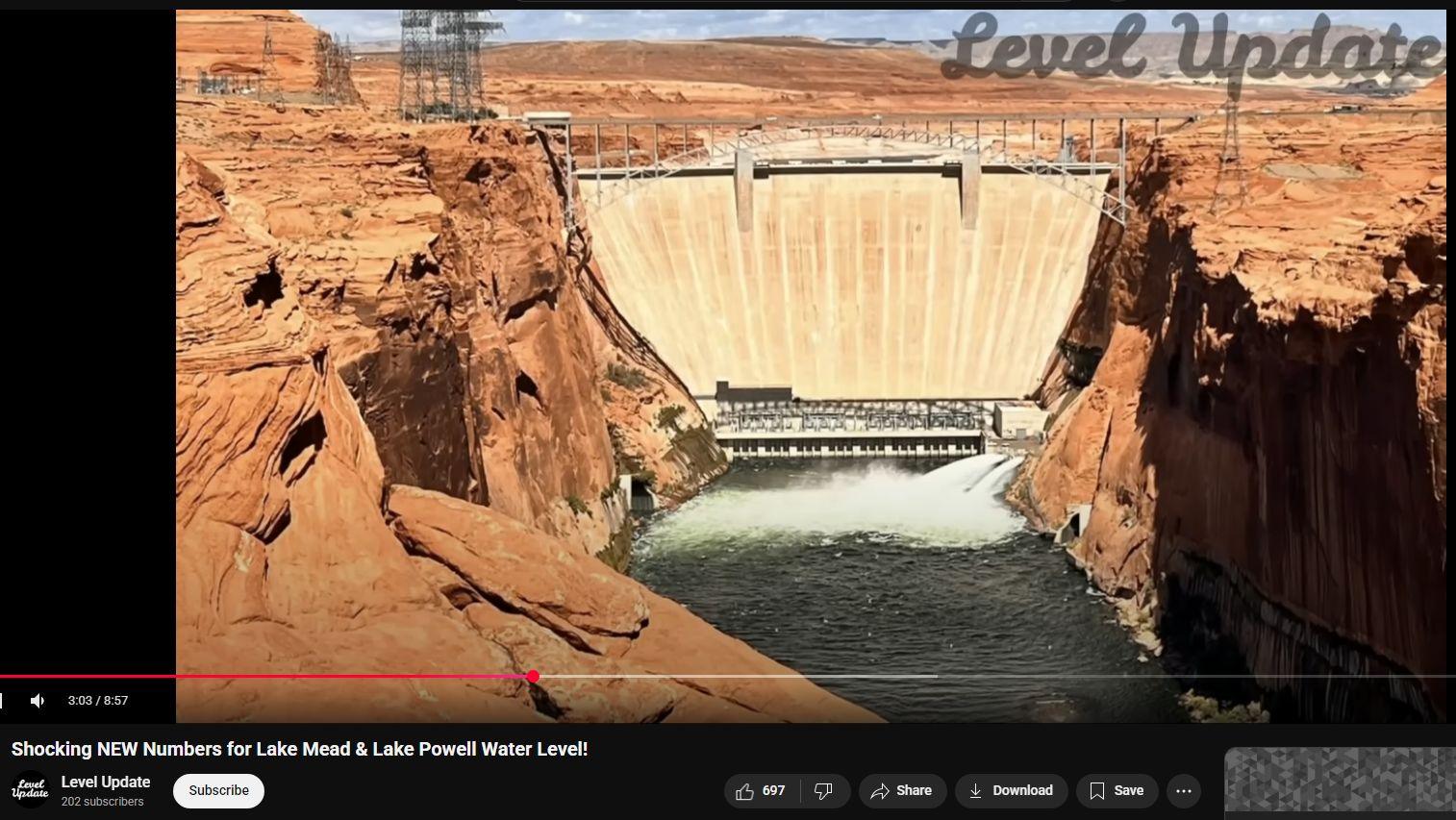
The consequence of this weather manipulation is catastrophic for the West’s two great reservoirs — Lake Mead and Lake Powell.
- Lake Mead now sits around 1,056 feet, hundreds of feet below full capacity, with projections that it could slide toward the “deadpool” level of 926 feet. If that happens, Hoover Dam will no longer be able to send water or power downstream.
- Lake Powell hovers near 3,546 feet, less than 30% of its capacity, with the critical hydro cutoff at 3,490 feet approaching fast.
These are not accidents. They are deliberate choke points. When the lakes fail, the energy grid fails with them. Hoover and Glen Canyon no longer generate power for tens of millions of people. The Southwest faces blackouts. Entire cities — Las Vegas, Phoenix, Los Angeles — will be forced into austerity.
The real weapon here is not just water, but power.
Manufactured Famine
Water is food. Without it, agriculture collapses. The Imperial Valley of California, one of the most productive farming regions in the world, depends on Colorado River water. Already, cuts are mandated. Alfalfa, wheat, lettuce, citrus, dairy feed — all shrinking. Cattle herds are being culled. Farmers are walking off their land.
The RF-engineered drought is not just a Western crisis — it will ripple across the entire continent. When food from the West disappears, shelves in Chicago, New York, and Miami go bare. Grain shortages turn into meat shortages. Fruits and vegetables become luxuries.
Famine in America is no longer a distant possibility. It is being manufactured step by step.
The Coming Water Wars
This is where the conspiracy sharpens into policy. Water scarcity is the perfect pretext for federal control and privatization. When reservoirs fall to critical levels, rationing begins. Cities will fight over allocations. States will sue each other. Behind the scenes, global water corporations wait to swoop in — offering “management,” “equity,” and “desalination projects” in exchange for total control.
The playbook is classic:
- Create scarcity through weather control.
- Collapse infrastructure by draining dams and shutting down hydropower.
- Force dependence on centralized, corporate, or federal control of water.
- Profit from crisis — while populations are weakened by famine, energy shortages, and chaos.
Energy Shortfall = Control
The genius of this operation is the linkage between water and energy. When the dams fail, the grid falters. When the grid falters, food distribution halts. Grocery stores go dark. Refrigeration stops. Pumps don’t move water. Hospitals lose backup capacity.
It is all interconnected. By controlling rainfall, the controllers don’t just dry up lakes — they dry up the very veins of civilization.
Conclusion: The Weaponization of Weather
This is not speculation. It is the lived reality of millions across the West who are watching their reservoirs vanish and their crops wither. The fingerprints of weather warfare are everywhere: pulsed NEXRAD radar signatures on storm maps, HAARP activity preceding high-pressure domes, and consistent patterns of moisture disruption timed perfectly to prevent replenishment of the Colorado River.
The dams are being shut down — not by chance, but by design. Water wars are here. Famine is coming. And unless people wake up to the weaponization of weather, America’s lifelines of food and power will remain under the thumb of those who control the sky.

Transcript
Click to reveal
Hello there and welcome to level update.
0:03
Lake me and Lake Powell are two of the
0:05
most critical reservoirs in the United
0:07
States. Both fed by the Colorado River.
0:11
Together they provide water to tens of
0:13
millions of people across Nevada,
0:15
Arizona, California, and beyond. Today,
0:19
we're taking a deeper look at their
0:20
current levels as of September 2025.
0:24
what the numbers reveal and why this
0:26
story matters for the future of the
0:28
American Southwest.
0:30
Starting with Lake Meade, as of
0:32
September 10, 2025, the reservoir stands
0:35
at about 1,056 ft above sea level.
0:39
That's a staggering 172 ft below its
0:42
full pool level of,29
0:45
ft. To put it simply, Lake me has lost
0:48
more than half of its capacity. And each
0:51
small drop matters because the lower the
0:53
water falls, the closer it gets to
0:55
critical shortage thresholds. Just since
0:58
yesterday, it slipped by 0.04 ft. That
1:02
doesn't sound like much, but over weeks
1:04
and months, those tiny decreases add up
1:07
to major impacts. The situation at Lake
1:11
Meade isn't new, but it is worsening.
1:14
Federal water managers have warned that
1:16
by July 2026, the reservoir could sink
1:19
below 1,50 ft, a mark that triggers a
1:23
tier 2 water shortage. That would mean
1:25
mandatory water cuts for states like
1:28
Arizona and Nevada. In the worst case
1:30
scenario, projections even show levels
1:33
falling to around 22 26 feet,
1:36
dangerously close to the so-called
1:38
Deadpool when water can no longer flow
1:41
through Hoover Dam to downstream
1:43
communities. Lake Maid is more than just
1:46
a water supply. It's also a source of
1:49
hydro power. The Hoover Dam generates
1:52
electricity for over a million people.
1:54
But as the lake drops, so does its
1:57
ability to produce power. With every 25
2:00
ft of decline, the dam's output shrinks
2:03
significantly. If levels approach 950
2:06
ft, hydro power generation could stop
2:09
altogether. That's not just a local
2:12
issue. It's a regional energy crisis in
2:14
the making. Now, let's shift upstream to
2:17
Lake Powell, the second largest
2:19
reservoir on the Colorado River. As of
2:22
September 9, 2025, Powell's elevation is
2:26
sitting at 3,546
2:28
ft above sea level. That's 153 ft below
2:33
full pool and means the lake is only
2:35
about 28% full. Over the past year,
2:39
Powell has lost around 33 feet of
2:41
elevation. And since its seasonal high
2:44
earlier this year, it's dropped by
2:46
another 31 ft. These numbers show a
2:49
reservoir in steady decline. For Lake
2:52
Powell, the consequences are especially
2:54
stark because it is home to Glenn Canyon
2:57
Dam, which also provides hydro power to
3:00
millions. If the lake falls below 3,490
3:03
ft, the dam may no longer be able to
3:06
generate electricity. Right now, Powell
3:09
is just about 56 feet above that minimum
3:12
threshold, which sounds like a cushion.
3:14
But at the current rate of decline, that
3:16
safety margin could vanish within a few
3:19
years if no major inflows arrive. Beyond
3:22
power, Lake Powell also represents
3:25
recreation, tourism, and even culture.
3:28
Falling levels have exposed hidden
3:30
canyons like the Cathedral in the
3:32
desert, places not seen since before the
3:35
dam was built in the 1960s. While that
3:38
offers a glimpse of natural beauty, it's
3:41
also a sobering sign of just how much
3:43
water has disappeared. Marinas have been
3:46
forced to close or relocate. Boat ramps
3:49
no longer reach the water. And what was
3:51
once a vast lake has now shrunk into
3:54
long, narrow channels.
3:57
Why are these reservoirs in such
3:58
trouble? The answer is a combination of
4:01
drought and overuse. The Colorado River
4:04
basin has been locked in a mega drought
4:06
for over two decades, one of the worst
4:09
in the past 1,200 years. Snowpack in the
4:12
Rockies, which feeds the river, has been
4:14
inconsistent and often melts too early,
4:17
reducing the runoff that usually refills
4:20
these lakes. On top of that, warmer
4:23
temperatures increase evaporation,
4:25
pulling even more water away from the
4:27
system. There's also the issue of
4:30
groundwater depletion. NASA satellite
4:32
studies have shown that the Colorado
4:34
River Basin has lost nearly 28 million
4:37
acre feet of groundwater in just 20
4:40
years. That's nearly the same volume as
4:43
the entire capacity of Lake Meade. This
4:46
hidden loss compounds the visible drop
4:48
in reservoirs, creating a double hit
4:51
that makes recovery even harder. The
4:54
human side of this story is just as
4:56
pressing. Roughly 40 million people
4:59
across seven US states and parts of
5:01
Mexico rely on water from the Colorado
5:04
River system. Farmers in Arizona and
5:07
California depend on it to irrigate
5:09
crops that supply much of the country.
5:12
Cities like Las Vegas, Phoenix, and Los
5:14
Angeles draw heavily from these lakes.
5:17
If water cuts deepen, it's not just
5:20
rural farmers who will feel it. Urban
5:22
households could face restrictions as
5:24
well. Looking ahead, policymakers face
5:28
tough choices. Current operating
5:30
guidelines for the Colorado River are
5:32
set to expire in 2026, and negotiations
5:36
are already underway to decide how to
5:38
share the shrinking supply. States are
5:41
under pressure to compromise, but
5:43
tensions run high because every drop
5:46
counts. Without a new agreement,
5:48
disputes over who gets water and who
5:51
doesn't will only intensify.
5:54
At the same time, there's innovation and
5:56
adaptation happening. Some cities are
5:59
recycling wastewater, investing in
6:01
desalination projects, and upgrading
6:04
irrigation systems to conserve water.
6:07
But even the most advanced technology
6:10
can't fully replace the scale of loss
6:12
these reservoirs are experiencing.
6:15
Conservation helps, but the sheer volume
6:17
of water missing from Lake Meade and
6:19
Lake Powell is so vast that solutions
6:22
must also address the root cause,
6:25
overallocation of the river. So the
6:28
story of Lake Meade and Lake Powell is
6:31
more than just numbers on a chart. It's
6:33
about the intersection of environment,
6:36
energy, and human survival. Every foot
6:39
of decline represents not only less
6:42
water, but also fewer options for the
6:44
future. If current trends continue, the
6:47
next decade could redefine the way the
6:50
American Southwest thinks about growth,
6:52
agriculture, and sustainability.
6:56
And as we close today's update, remember
6:58
this. These reservoirs are a mirror
7:01
reflecting how human activity. Whether
7:04
levels stabilize or continue to decline
7:08
will depend on both nature's cycles and
7:10
the choices we make as a society. The
7:14
Colorado River may no longer be able to
7:16
sustain the same promises it once did.
7:19
And facing that reality may be the
7:22
biggest challenge of all. Despite the
7:25
challenges facing Lake Meade and Lake
7:27
Powell, there's still room for optimism.
7:30
Every conservation effort, every
7:32
agreement between states, and every
7:34
breakthrough in water management
7:36
technology, helps buy more time. Nature
7:39
can also surprise us. One strong winter
7:42
snow pack can bring temporary relief,
7:45
reminding us that recovery, while
7:47
difficult, is still possible. What
7:50
matters now is awareness and action. By
7:53
staying informed, supporting smart
7:55
policies, and making small changes in
7:58
our own water use, we can all be part of
8:00
the solution. Together, there's hope
8:03
that these iconic lakes can remain a
8:06
vital resource for future generations.
8:09
Thanks for watching today's update. If
8:11
you found this video helpful, don't
8:13
forget to hit the like button, subscribe
8:15
to the channel, and turn on
8:17
notifications so you never miss the
8:19
latest water level reports and climate
8:22
updates. Share this video with others
8:24
who care about the future of the
8:26
Colorado River, and let's keep the
8:28
conversation going in the comments
8:30
below. Together, awareness and action
8:33
can make a real difference. Until next
8:36
time, stay informed, stay prepared, and
8:39
I'll see you in the next video.
Lake Mead
- As of Sept 10, 2025, elevation ~ 1,056 ft above sea level. (wp.4sci.org)
- That is 172 ft below its “full pool level.” (wp.4sci.org)
- Loss of “more than half of its capacity.” (wp.4sci.org)
- Prediction: by July 2026, the reservoir could sink below 1,050 ft, triggering a “tier 2 water shortage.” (wp.4sci.org)
- In a “worst case scenario,” levels could fall to “around 926 feet,” which is “dangerously close to the so-called ‘Deadpool’” level — where water can no longer flow through Hoover Dam to downstream communities. (wp.4sci.org)
- Another critical threshold: if lake levels approach 950 ft, hydro power generation “could stop altogether.” (wp.4sci.org)
Lake Powell (Glen Canyon Dam)
- As of Sept 9, 2025, elevation ~ 3,546 ft above sea level. (wp.4sci.org)
- That is 153 ft below full pool. (wp.4sci.org)
- The lake is “about 28% full.” (wp.4sci.org)
- Over the past year, lost ~33 ft of elevation; since its seasonal high earlier this year, dropped another ~31 ft. (wp.4sci.org)
- Critical threshold: if the lake falls below 3,490 ft, the dam may no longer be able to generate electricity. It’s currently ~56 ft above that minimum. (wp.4sci.org)
Causes & Consequences
- Drought, climate change: mega-drought over two decades, reduced snowpack, warmer temps = more evaporation. (wp.4sci.org)
- Groundwater depletion in the basin: ~28 million acre-feet lost in 20 years, “nearly same volume as entire capacity of Lake Mead.” (wp.4sci.org)
- Impacts:
- Hydropower threatened (Hoover Dam, Glen Canyon Dam).
- Water supply cuts/mandatory restrictions (for states like Arizona, Nevada, etc.).
- Impacts on agriculture, cities (Las Vegas, Phoenix, Los Angeles).
- Recreation, tourism, exposed landscapes (boat ramps, marinas, submerged features resurfacing).
- Timing:
- Tier 2 water shortage for Lake Mead possibly by July 2026. (wp.4sci.org)
- For Lake Powell, the “safety margin” (above the 3,490 ft electricity cutoff) could vanish “within a few years” under current trends. (wp.4sci.org)
Evaluation: What Seems Plausible vs What Might Be Exaggerated or Misleading
Here are points where the article seems plausible, and where caution is needed.
| Aspect | Likely/Well-Supported | Possibly Exaggerated or Unclear |
|---|---|---|
| Current levels being substantially below full pool | It’s well known Mead & Powell are far below “full pool” in recent years. A drop of 150-200 ft below full pool is consistent with other reporting. | The exact ft differences, how “full” is defined, etc., may be slightly off depending on which “full pool” benchmark is used. |
| Risk of water cuts / shortage | Very plausible — shortage tiers for Colorado River have been enforced and discussed; basin states are already under stress. | The date (“by July 2026”) is a projection; many variables (inflow, snowpack, policy) could change whether that happens or not. |
| Hydropower cutoff thresholds | It is true that hydropower depends on “head” (water level), and at some low level dams like Hoover or Glen Canyon can become unable to generate electricity reliably. | “Stop altogether at 950 ft” for Mead, or at 3,490 ft for Powell — these are thresholds that might reflect some engineering minimums, but usually there is “emergency generation” or reduced capacity rather than a binary “on/off”. The article’s threshold numbers may simplify or omit nuances (e.g. reduced capacity vs zero generation). |
| “Deadpool” attribution / catastrophic failure | The concept of “deadpool” (i.e. reservoir so low that no water can flow through dam outlets) is real, and many discuss it as a risk. | Claiming Mead could hit “deadpool” around 926 ft is dramatic; whether that’s realistic by mid-2026 or even in the next few years depends strongly on inflows, weather, water usage policies, etc. It feels like a worst case scenario, not a certain outcome. |
| Groundwater depletion & climate effects | Those are well-documented contributing factors. Loss of snowpack, early melt, rising temperatures all reduce runoff. Groundwater overuse in the basin is also real. | The comparison “nearly the same volume as entire capacity of Lake Mead” for lost groundwater is striking; even if roughly correct, groundwater loss is very heterogenous and has different usability than reservoir water (difficulty of accessing, distribution, etc.). The article implicitly equates them. |
What to Check / What Data Would Be Helpful
To assess how close we are to the “catastrophic” thresholds, one would want:
- Real, up-to-date reservoir levels from official sources (U.S. Bureau of Reclamation, USBR), for Mead & Powell: elevation, storage volume, percentage of full.
- Official “deadpool” & “minimum power generation” elevations for Hoover Dam and Glen Canyon Dam.
- Trends in inflows (snowpack, precipitation forecasts), demand (water use), and policies under negotiation (e.g. new operating agreements for the Colorado River).
- Climate model projections for precipitation/snowpack in the Colorado River basin.
Overall Verdict & “Catastrophe” Timeline (Based on Article)
- The situation is serious and deserving of attention. The reservoirs are very far below full, hydropower is under threat, water cuts seem likely in many places.
- But the article frames many of its statements as potential or “worst-case” scenarios. So while the risks exist, many of the more dramatic outcomes (deadpool, zero hydro power, extremely low elevations) are not guaranteed.
- The timeline (e.g. Mead dropping below tier 2 by mid-2026, Powell losing its safety margin within “a few years”) is plausible under continued drought and no compensating inflows or demand reductions — but there’s uncertainty.